

An Tiaracht [Tearaght Island]
Good walks are even better shared.
V1894 : Tearaght Island
David Purchase Photo source
Overview
An Tiaracht [Tearaght Island]
Introduction
Nestled off the southwestern coast of Ireland in County Kerry, An Tiaracht, also known as Tearaght Island, is a hidden gem for outdoor enthusiasts. At an elevation of 168 meters, this Marilyn offers breathtaking views and a touch of history, primarily thanks to its iconic lighthouse.
Geology
Tearaght Island boasts Old Red Sandstone geology, providing a spectacular display of red and brown rock formations. The coastal cliffs not only make for spectacular photographs but also a dramatic backdrop for your hiking experience.
Routes
The highlight walking route is the Tearaght Island Circular Walk. This moderately challenging trek covers about 3.5 kilometres along the island’s perimeter. Expect to spend around 1.5 hours soaking in the natural beauty and occasionally wondering if the island’s sheep are judging your walking capabilities.
Summit Features
At the summit, you'll find the historic lighthouse, constructed in 1856. This remarkable structure not only guides ships but also serves as the crown jewel of the island, offering panoramic views from its vicinity.
Terrain Type
The terrain consists of rocky and grassy patches with well-defined paths, particularly close to the cliffs. Good hiking boots are recommended, though the sheep may not give you any fashion points.
Views
From the top, prepare to be awestruck by views that stretch across the Atlantic. The Skellig Islands and the Blasket Islands are visible on a clear day.
Best Seasons
The best time to visit for jaw-dropping views is late spring and early summer, where the weather shines brighter than your hiking shorts. Autumn brings along picturesque sunsets, perfect for those Instagram moments.
Hazards
Adventurers should be mindful of the strong winds that sweep across the cliffs, as well as potentially slippery paths. Always check the weather forecast before your sauntering so as not to be caught surprised by a sudden squall.
Access
The nearest parking is located at the harbour in Ballinskelligs, the launch point for boat trips to Tearaght Island. Public transport is limited, so a car will make your life easier.
Nearby Facilities
While Tearaght itself is a tapestry of natural beauty, the nearest facilities like shops and cafés are found in Ballinskelligs. Remember to hydrate and refresh before or after your outing.
History
The name An Tiaracht reflects the island’s Irish roots, meaning 'the island of the stony place'. Historically, it has served as an essential waypoint for sailors navigating perilous waters.
With its stunning vistas, a sense of history, and the companionship of sheep, An Tiaracht is nothing short of a must-visit for those yearning for adventure in the great outdoors.
Pack your bags and let this island surprise you—with its beauty, it may even have the last laugh!
Explore routes near An Tiaracht [Tearaght Island]
Walks starting near this hill. Open a route to check its map, distance and full itinerary.
Route planning notes
These notes describe possible approaches. Check a route's map and access information when planning your walk.
Tearaght Island Circular Walk
A scenic circular route around the island showcasing dramatic coastal cliffs and stunning views of the Atlantic Ocean.
Make a day of it, together
Find someone to share the walk with, or organise a day out along a route you like.
Photo Gallery
View all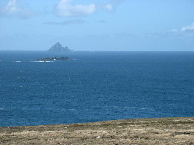 Photo could not load
V1894 : Tearaght Island
David Purchase
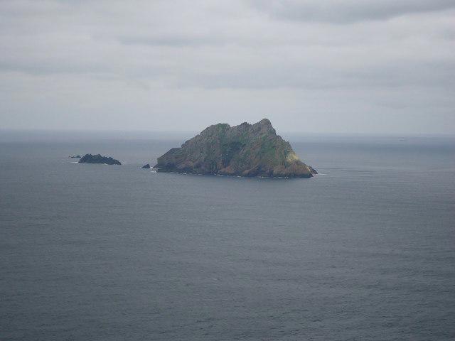 Photo could not load
V1894 : Tearaght Island
Michael Earnshaw
Hill facts and local notes
Classifications
Elevation
200m
656 ft
Prominence
200m
Coordinates
52.0766, -10.6540
V181949
OS Map
70
At the Summit
The summit features a prominent lighthouse, which was built in 1856, providing a historic touch alongside breathtaking views.
Terrain & Geology
Tearaght Island is primarily composed of Old Red Sandstone, which is renowned for its rich red and brown hues. The rugged rock formations create dramatic cliffs and beautiful coastal features.
Views & Scenery
From the summit, one can see the Skellig Islands, the Blasket Islands, and the vast expanse of the Atlantic Ocean.
History & Heritage
Name Origin
An Tiaracht translates to 'the island of the stony place' in Irish.
Historical Significance
The island has been a significant landmark for sailors, and the lighthouse has a storied history in maritime navigation.
Getting There & Facilities
Parking
Parking is available at the small harbour in Ballinskelligs, which is the point of departure for boat trips.
Public Transport
Limited public transport options; visitors may need to take a taxi or drive.
Nearby Facilities
Basic facilities available in Ballinskelligs including a small shop and a café. Toilets can be found at the harbour.
Safety Information
Known Hazards
- Strong winds and slippery paths along the cliffs require caution. Be mindful of the weather, as conditions can change rapidly.
General Safety Tips
- Check weather conditions before setting out
- Carry appropriate clothing and equipment
- Let someone know your planned route
- Take a map, compass, and GPS device
- Carry emergency supplies: food, water, first aid kit, torch
Hills
Some common questions about the hills answered
Are there group walks up An Tiaracht [Tearaght Island]?
Many walkers use Walkmates to join or organise walks with others. You can check for group walks around An Tiaracht [Tearaght Island] through the maps
Are there other walkers around An Tiaracht [Tearaght Island]?
Activity varies by location and time, but Walkmates lets you see whether others have shared walks or shown interest in this area. Find other people through the walking friends search walking friends for An Tiaracht [Tearaght Island] search or of course create your own walk for An Tiaracht [Tearaght Island]
Can I organise a walk to An Tiaracht [Tearaght Island]?
Yes. If there aren’t any walks listed already, you can create a walk and make it available for others to join.
If you're signed up to Walkmates, you can create a walk to An Tiaracht [Tearaght Island].
How do I find a walk up this hill?
There are often multiple ways to walk this hill, depending on experience and route preference. Walkmates helps you explore walks and routes that others have shared.
Can I suggest a new route up An Tiaracht [Tearaght Island]?
Yes. You can suggest or create routes to share with others. Walkmates focuses on the social side of walking, so routes are used to help people organise walks and explore areas together, rather than as detailed navigation tools or route libraries.
Other uses really appreciate knowledgeable walkers sharing their routes. Share your favourite route to An Tiaracht [Tearaght Island] here
The is an error or something incorrect about this hill. How do I let you know?
We always strive to keep the information on Walkmates as accurate as possible. If you find an error, please let us know through the contact form and we'll aim to correct it as quickly as possible
Community Discussion
Comments
Location
![An Tiaracht [Tearaght Island] location map](https://cdn.walkmates.com/hill-maps/hill-sources/20558/52.07663_-10.65398.png)
Grid reference: V181949
View on OpenStreetMapOpens a map in a new tab, centred on the hill.
No comments yet. Be the first.